_by_Diogo_Ribeiro._Original_from_The_Beinecke_prep%2001.jpg) |
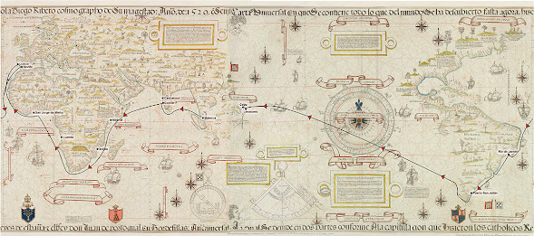
| Diogo Ribeiro's 1529 Vatican Planisphere. (Source.) |
Diogo Ribeiro's Early Career
 |
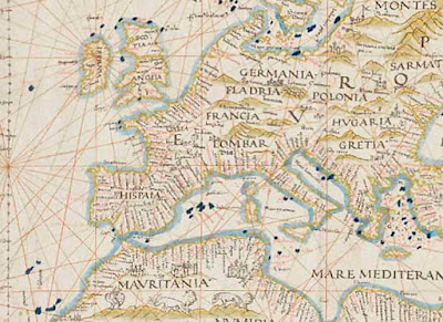
| Europe as shown on Ribeiro's Vatican Planisphere. |
 |
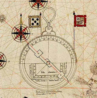
| Astrolabe from Ribeiro's Vatican Planisphere. |
Ribeiro After Magellan's Departure
In 1524, Ribeiro helped the Genoese ambassador Martin Centurion make a Spanish translation of the Book of Duarte Barbosa (Portuguese: Livro de Duarte Barbosa), a Portuguese guide to the trading ports of East Africa, India, and what was known of Asia at the time.[2]
Portugal had tried to protect its growing knowledge of geography and navigation, making it illegal to bring charts and maps out of the kingdom, but Ribero and the other defectors had taken it all with them to Seville and combined the Portuguese knowledge base with the newest information collected by Spanish explorers.
Ribeiro's Padrón Real Maps
Ribeiro is best known for his versions of the Padrón Real, the official template that, regularly updated, was used for maps on all Spanish expeditions. Cartographers and pilots who contributed to the Padrón Real included Ribeiro, Amerigo Vespucci, Sebastian Cabot, Alonzo de Santa Cruz, and Juan Lopez de Velasco.
Another of the Portuguese defectors, Estêvão Gomes, had made at least one voyage to India with the Portuguese and became a rival of Magellan’s in Seville, proposing his own expedition to King Charles. When Magellan’s plan was chosen, Gomes was named pilot major of Magellan’s fleet, where friction between the two men grew. Gomes was one of two officers who at the mouth of the strait took charge of the San Antonio and deserted, sailing back to Spain, bringing with them badly needed provisions.
 |
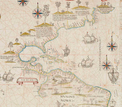
| The Americas on Ribeiro's Vatican Planisphere. |
In 1524, Gomes joined a new expedition across the Atlantic seeking a northwest passage that would be a shorter route to the Moluccas than Magellan’s. After failing to find one Gomes returned to Spain, and (like Christopher Columbus) he didn’t want to return empty-handed, so he kidnapped a number of “Indians” in Maine or Nova Scotia. At least fifty-eight survived.
Ribeiro took one of them into his home, a man (also) christened Diogo who had learned some Spanish and served as an interpreter. Ribeiro used information obtained from Diogo and the expedition’s crew to complete a map known as the Castiglione map. The information allowed him to fill an important gap along the North American coastline. (The area Gomes charted is listed on the map above, top center, "Tiera de Esteva Gomez.")
In 1529 and 1530 Ribeiro created the series of world maps he is best known for, the 1529 “Vatican” (also Borgian) map (top), the 1527 Weimar map, and the 1530 Wolfenbuttel map, three versions of the official Padrón Real. These show the full extent of the Pacific Ocean along with as much North American coastline as had been charted. The west of North America and much of South America is left blank.
Among Ribeiro’s final efforts was the invention of a metal pump that could empty ships’ bilgewater more efficiency and the pump was tested successfully, though before it could be widely adopted, a less-expensive wooden pump of similar power hit the market. Ribeiro died in August 1533. His date of birth is unknown, but if he sailed in da Gama’s armada as a young man, by 1533 he would have been in his fifties.
One thing that’s clear: Diogo Ribeiro was a renaissance thinker as opposed to a medieval man. Columbus by contrast believed firmly in the old maps and when he reached the Caribbean he was certain he had landed in the East Indies and that not far beyond lay Japan and China—a mistaken view he would insist on to his death. The old maps and the Scriptures showed only Europe, Africa, and Asia, and most Europeans of Columbus’s generation couldn’t conceive that the old maps and the Holy Scriptures might be wrong.
Ribeiro, conversely, continually learned and worked to discover what the wisdom of the ages could not offer. And just as the Renaissance humanists often wrote, painted, studied, and even invented, Ribeiro pursued interests in every field related to cartography and geography, right down to sailing and exploring, and manufacturing the technology and equipment involved.
A separate post on Ribeiro's Vatican Planisphere will follow soon.
Notes
1. Portuguese: Diogo Ribeiro; Spanish: Diego Ribero or Rivero.
By John Sailors,
Enrique of Malacca's Voyage
Sources
Vigneras, L. A. “The Cartography of Diogo Ribeiro.” Imago Mundi Ltd.
Joyner, Tim. Magellan. International Marine, Camden, Maine. 1992.
Brotton, Jerry. “A History of the World in Twelve Maps: From Ptolemy to Google Earth, the world has been mapped by visionaries.” Time, 2013.
Wikipedia Links
Diogo Ribeiro. A good writeup with a links to high-resolution images of Ribeiro's work.
 |
| Map of Enrique of Malacca's circumnavigation: Malacca, Lisbon, Seville, Rio de Janeiro, Puerto San Julián, Guam, Limasawa, Cebu.[1] |
On March 28, 1521, Enrique of Malacca became the first person to complete a linguistic circumnavigation of the globe—he traveled so far in one direction that he reached a point where his own language was spoken. Enrique’s journey began a decade earlier following the sack of Malacca, when he was taken as a slave by Ferdinand Magellan. A teenager, he accompanied Magellan back to Portugal, then to Spain, and finally on the Armada de Molucca to locate a westward route to the Spice Islands. More about Enrique of Malacca.
