
 |
|
The Fra Mauro map (1450), one of the first in Europe to show Africa as a free-standing continent (see top). |
(Updated, 8/23/22)
The Fra Mauro map gave Portugal solid reason to turn down Columbus's 1480s proposal to sail west to the Indies.
The giant map at St. George's Castle in Lisbon was the first in Europe to show Africa as a free-standing continent surrounded by a waterway around the far tip. It challenged the widely accepted view of Ptolemy that the Indian Ocean was a closed-in sea.
 |
| Fra Mauro's Africa. |
This was an impoverished nation on the far edge of European civilization. But Portugal's isolated geography suddenly offered huge prospects—in Africa. First and immediate were gold and slaves from the continent. Beyond that were dreams of a river route to the Nile and the legendary kingdom of Prester John, and possibly a greater holy grail, a sea route to the Indies bypassing the Middle East and Islam.
Two original editions of the map were produced by the Italian cartographer Fra Mauro and a team of cartographers and artists in Venice, a project that took several years. Portugal's edition was commissioned by King Alfonso V, the other by the Signoria of Venice, the supreme governmental body of the republic. The latter has survived and is on public display in the city.
The huge Fra Mauro map is 2.4 X 2.4 meters and oriented to the south (upside-down) in the Arab tradition. It contains several thousand textual commentaries taken from accounts of travelers such as Marco Polo and Niccolò de' Conti. They include also new discoveries by the Portuguese.
 |
| Fra Mauro's Asia, with Africa on the right. |
To Portugal, Fra Mauro's work was a treasure map. It provided that holy grail of a sea route to the Indies, one that would allow access to spices such as cloves that the entire continent craved. Since the fall of Constantinople in 1453, the spice trade had been controlled by Islamic traders.
King João II and his advisers turned down Columbus's proposal for a number of reasons, but Portugal was already committed to seeking a route around Africa.
It turned out to be a good bet. Within two decades Portugal was brutally establishing a secret trade network and empire at ports in East Africa and India, where Ferdinand Magellan would get his early experience as a soldier. Both Magellan and Columbus underestimated the size of the Earth, by, coincidentally, roughly the width of the Pacific Ocean. As a result, the strait Magellan later found for Spain never did pay off.
Fra Mauro's spherical map of the Earth is surrounded in the four corners by small spheres, one showing the solar system according to Ptolemy, one the four elements, one the Garden of Eden, and one the Earth as a globe.
NASA created the comparison below that matches the Fra Mauro map to a satellite image. The matchup shows Fra Mauro was closer to the real shapes of continents and land masses than first impression suggests.

By John Sailors
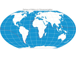
Enrique's Voyage
_______________
Images
Fra Mauro map: Piero Falchetta, Public Domain, https://commons.wikimedia.org/w/index.php
Fra Mauro–NASA Image: By NASA - http://landsat.gsfc.nasa.gov/wp-content/uploads/2014/01/Fra-Mauro_Global-comparison-south.jpg, Public Domain, https://commons.wikimedia.org/w/index.php?curid=38697958
(C) 2021 by John Sailors. All rights reserved.
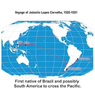
Ferdinand Magellan’s historic journey swept up several unlikely travelers along the way, among them a seven-year-old boy at Guanabara Bay (Rio de Janeiro). Half-Portuguese, half-Tupi Indian, he is remembered in history as Joãozito Lopes Carvalho. The young boy became the first native of Brazil and likely all of South America to cross the Pacific Ocean—on a year-and-a-half journey that for him ended at Brunei five hundred years ago this summer.

Antonio Pigafetta's account of the Magellan-Elcano voyage gives us both first-hand historical detail and color—the human aspects of the journey. The Italian scholar learned all he could about the cultures that Magellan's fleet encountered, even sitting down and recording samples of languages.
An excellent example of Pigafetta's curiosity and fascination is his description of the coconut and the palm tree, which he learned about soon after the fleet's arrival in the Philippines. Like the pineapple Magellan tried in Rio, the coconut was an unknown. "Cocoanuts are the fruit of the palmtree. Just as we have bread, wine, oil, and milk, so those people get everything from that tree. Read more.
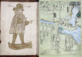
It gets little mention today, but The Travels of Sir John Mandeville was a world atlas of sorts in medieval Europe, essential reading for navigators and explorers. The accounts became circulated widely in Europe in the fourteenth century. They detail travels in North Africa and the Middle East, and in India, China, and even the Malay Peninsula—which would have been of particular interest to Ferdinand Magellan, and also Enrique of Malacca, Magellan’s interpreter-slave. Read more.
Reni Roxas and Marc Singer brought the story of Enrique to life for children in First Around the Globe: The Story of Enrique. Twenty years on they released this anniversary edition in 2017 from Tahanan Books, Manila. Read more.
- EnriqueOfMalacca.com
- Enrique of Malacca on Twitter
- Enrique of Malacca on Facebook
- John Sailors / Enrique on Medium
- And, yes, Enrique might be 500 years old, but he was known as a kid, so of course he's now on Instagram too.