 |
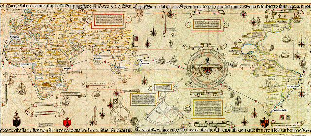
| Map of Enrique of Malacca's circumnavigation. (Source: Enrique's Voyage.) |
This map shows Enrique of Malacca's route around the globe from Malacca in 1512 to Cebu in 1522. The ten-year journey started with a tour of Portugal's still-secretive maritime empire along the coasts of India and Africa, followed by six years in Lisbon and Seville—and finally on Magellan's historic enterprise to seek a strait leading to the South Sea and Southeast Asia.
The above map is Diogo Ribeiro's 1529 Vatican Planisphere (source), altered to center on Enrique's starting and end points, Malacca and Cebu. The original has the Atlantic Ocean in the center with the Pacific stretching to the left and Asia to the right.
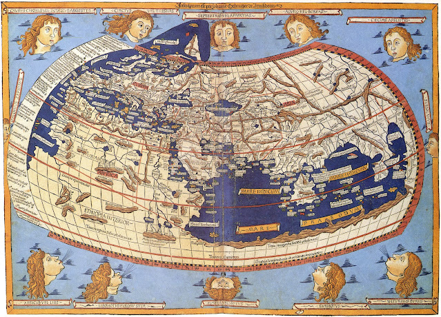
The maps below show roughly a century's progress in Europeans' charting of the world beyond the continent, beginning with the Greco-Roman worldview inherited from Ptolemy.
 |
| Ptolemy world map created by Lord Nicolas the German in 1482. (Source: Ptolemy.) |
The Ptolemy (tä-lə-mē) world map shows the world as it was known in the Greco-Roman world in the second century CE. These maps were created based on descriptions in Claudius Ptolemy’s book Geography, written about 150 CE. No original maps from the book itself have ever been discovered.
Claudius Ptolemy (Latin: Claudius Ptolemaeus) (c. 100 CE — c. 170 CE) was a Greek astronomer, mathematician, and geographer who lived in Alexandria during the 2nd century CE. Read more.
-W-2000%20-%20web.jpg) |
| The Fra Mauro map (1450), one of the first in Europe to show Africa as a free-standing continent (see top). (Source.) |
The Fra Mauro map gave Portugal solid reason to turn down Columbus's 1480s proposal to sail west to the Indies.
The giant map at St. George's Castle in Lisbon was the first in Europe to show Africa as a free-standing continent surrounded by a waterway around the far tip. It challenged the widely accepted view of Ptolemy that the Indian Ocean was a closed-in sea. Read more.
.jpg) |
| The Cantino planisphere, c. 1502. (Source.) |
The Cantino planisphere is the earliest-surviving map that shows Portuguese discoveries in Asia and South America up to 1500.
The map is a guidebook to their voyages, its detail showing where they had ventured, and less or none where they had not. It contains considerable accuracy of both the west and east coasts of Africa, which by that time they had thoroughly explored. To the east beyond Africa the detail fades, along the coast of India and into Asia. Read more.
 |
| The Contarini-Rosselli world map (1506). (Source.) |
The Contarini-Rosselli map, engraved in copper in 1506, was one of the first to show the New World. It was designed by Giovanni Matteo Contarini and engraved by Francesco Rosselli. Their names and the date are indicated in Latin on the map next to the Cape of Good Hope. The map is a fan-shaped, coniform projection. It was discovered in 1922 and is currently housed at the British Library.
The maps made just after 1500 record the progress of European exploration. The Contarini-Rosselli map shows Spanish and Portuguese discoveries in the Americas, Africa, and India. These include world maps by Contarini-Rosselli, Johann Ruysch, and Martin Waldseemuller, as well as the Cantino planisphere. Read more.
 |
| Johannes Ruysch 1508 world map. (Source.) |
If you plot Leif Erikson's voyage of discovery on Johannes Ruysch’s world map of 1508, the Viking explorer reaches not just Newfoundland but the easternmost point of the Asian continent, a land he labeled “Terra Nova” (New World).
Given the knowledge of the day—five years before Vasco Núñez de Balboa found the “South Sea”—Ruysch missed the existence of North America and the Pacific Ocean. In this way the map serves as a window into the worldview of Christopher Columbus, who believed to the end that Japan and China lay not far beyond Hispaniola. Read more.
_by_Diogo_Ribeiro._Original_from_The_Beinecke_prep%2001_web.jpg) |
| Diogo Ribeiro's 1529 Vatican Planisphere. (Source.) |
Key Maps
• Ptolemy World Map
• Fra Mauro Map
• Cantino Planisphere
• Contarini-Rosseli Map
• Johannes Ruysch World Map
• Diogo Ribeiro's World Maps
(C) 2023, by John Sailors.
