 |
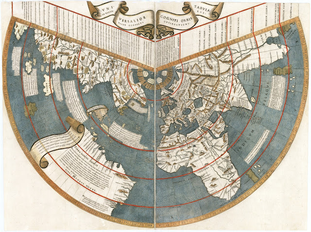
| Johannes Ruysch world map. |
If you plot Leif Erikson's voyage of discovery on Johannes Ruysch’s world map of 1508, the Viking explorer reaches not just Newfoundland but the easternmost point of the Asian continent, a land he labeled “Terra Nova” (New World).
Given the knowledge of the day—five years before Vasco Núñez de Balboa found the “South Sea”—Ruysch missed the existence of North America and the Pacific Ocean. In this way the map serves as a window into the worldview of Christopher Columbus, who believed to the end that Japan and China lay not far beyond Hispaniola.
Ruysch puts Asia’s eastern extreme north of Columbus’s Hispaniola and Cuba, and the continent’s northern tip is closer to Iceland than any part of Europe is. At the time, Europeans were left to imagine East Asian geography from sources they found in India and elsewhere; the existence of the Pacific came as a surprise to Europeans.
Ruysch produced the map in 1507 for a 1508 edition of Ptolemy’s Geography, printed in Rome. Like Giovanni Matteo Contarini and Francesco Rosselli with their world map two years earlier, Ruysch used a conic projection that put the Atlantic Ocean in the center. The two maps have many similarities.
India and Africa
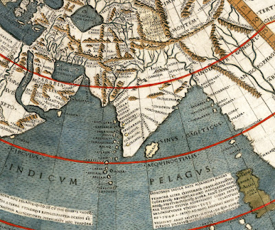
A notable improvement, Ruysch depicted India as a full peninsula with a shape close to correct. He may have benefited from an additional spice fleet's charting. Along India’s west coast, Ruysch names about ten Indian cities Portugal had visited, among them Cambay, Cananor, and Colchin (his spellings of Khambhat, Kannur, and Kochi).
 |
| Ruysch World Map India. |
To the subcontinent’s southeast, the map adds Sri Lanka, but south and east of that Ruysch runs out of solid data. The Portuguese wouldn’t visit Malacca and Sumatra until 1509, or the Moluccas, or Spice Islands, until a few years later.
As on the Contarini-Rosselli map, Ruysch shows a well-charted African coast, though displaying little knowledge of the continent’s interior. Ruysch has Aethiopia located in Nigeria, and Libya placed around Mali. Ruysch did add Madagascar, though too far south and too far east (similar to the island’s placement on the Cantino Planisphere of 1502).
 |
| Ruysch World Map Africa. |
The Atlantic and Asia
West of the Atlantic, the Ruysch map is the second-oldest known to show the New World, after the Contarini-Rosselli map. Judging by the two maps’ similar take on the Atlantic and Asia, it’s likely Ruysch was influenced by or copied the slightly earlier map.
 |
| Ruysch World Map Atlantic. |
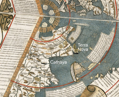
And as with the Contarini-Rosselli map, Ruysch shows Hispaniola and Cuba midway to Asia, above a southern continent to their south that shows Brazil at its top. And both maps show a strip of continent protruding westward from northern Asia, beginning at Cathay. On the southeastern tip of that stretch, Ruysch names one region Terra Nova (New World)—just north of Barbatos [Barbados] Island.
Ruysch may have sailed with John Cabot’s 1497 expedition that discovered Newfoundland, which would explain the name Terra Nova.
 |
| Ruysch World Map East Asia. |
When Columbus reached Hispaniola and Cuba, he believed he had neared the Asian mainland, with Japan and China lying not far beyond. The North American coast had yet to be charted.
On these projections, Southeast Asia winds up in the top left corner. Contarini added Java, while Ruysch added both a Java Major and southwest of that a Java Minor—the names of Java and Sumatra passed on by Marco Polo. Inscriptions give information on both.
 |
| Ruysch World Map Southeast Asia. |
It’s noteworthy that Columbus died in 1506, a year before Ruysch created this map and—also in 1507—Martin Waldseemüller created the first map to use the name America, which he got from the explorer Amerigo Vespucci. It was Vespucci who pushed the theory that the Europeans were exploring not islands but a continent.
Johannes Ruysch
Some documents described Johannes Ruysch (aka Giovanni Ruisch) as German, others as Flemish. He was likely born in the Low Countries (Netherlands). Around 1498, Ruysch joined at least one expedition, possibly John Cabot’s to Newfoundland, and around 1505 he entered the Benedictine monastery of St. Martin in Cologne. He later left for Rome, where he made the world map he is remembered for.
Ruysch World Map vs. Contarini-Rosselli Map
Compare the Ruysch and Contarini-Rosselli maps below. The Contarini-Rosselli map, engraved in copper in 1506, was one of the first to show the New World. It was designed by Giovanni Matteo Contarini and engraved by Francesco Rosselli.
 |
| Contarini-Rosselli world map, 1506. |
 |
| Ruysch world map, 1507–08. |
By John Sailors
EnriqueofMalacca.com
Images:
Maps: By Johannes Ruysch. Library of Congress. https://www.loc.gov/exhibits/treasures/images/vc00map.jpg.
(C) 2022, by John Sailors.
Maps
• Ptolemy World Map
• Fra Mauro Map
• Cantino Planisphere
• Contarini-Rosselli Map
• Johannes Ruysch World Map
.
Frequently Asked Questions
• What was Enrique of Malacca’s Real Name
• What was Enrique of Malacca’s Cause of Death?
• Was Enrique First to Circumnavigate the Earth?
• Where was Enrique of Malacca from?
• Was Enrique of Malacca Filipino?
- EnriqueOfMalacca.com
- Enrique of Malacca on Twitter
- Enrique of Malacca on Facebook
- John Sailors / Enrique on Medium
- And, yes, Enrique might be 500 years old, but he was known as a kid, so of course he's now on Instagram too.

